Between the Reaches – 1st Edition
Introducing the Joint Thames Strategy and the TEP Newsletter
Welcome to the first edition of the Between the Reaches Newsletter!
The River Thames is one of the most iconic and pivotal elements in London. As climate pressures grow, it is essential to ensure that we consistently protect the health of the river, as well as improve our relationship with it.
In line with this, the Joint Thames Strategy has set out a landmark programme to collaboratively secure the long-term climate resilience of the Thames from "Surrey to the Sea".
This newsletter, Between the Reaches, has been designed to be a vehicle for our team at TEP to connect with all of you! We want to showcase our work and, most of all, hear from you on how we can improve it.
In this first edition, we have set out to give you an introduction to the Joint Thames Strategy. Alongside this we ask you: “How can we improve our relationship with the riverside?”
We want to know how you have interacted with the river, the challenges you have noted, and the opportunities you think we are missing out on to create the most connected, thriving and healthy riverside for you and your community.
If you would like to take part in the survey, please following this link. All answers and experiences are welcome and appreciated!
We are really excited to share this incredible project with you and to collaborate in creating a unified voice for a resilient Thames.
Background to the Joint Thames Strategy
The Joint Thames Strategy (JTS) programme is a holistic, place-based multi-partner climate resilience initiative that is taking the form of a toolkit that local authorities and other organisations can use when adapting riversides to the risk of rising sea levels. It aims to align local aspirations with the Thames Estuary 2100 Plan, ensuring flood resilience is in their decision making.
This programme includes updating of three existing Thames Strategies and creating one new strategy. These being:
The Thames Landscape Strategy (refreshed)
The Thames Strategy Kew to Chelsea (refreshed)
The Thames Strategy London Central (new)
The Thames Strategy East (refreshed).
The four strategies will, collectively, provide a geographically continuous framework to enable local authorities and other public bodies to deliver the adaption and mitigation measures needed to support the TE2100 Plan.
The Thames Landscape Strategy (Weybridge to Kew) is a partnership organisation between the local authorities of Richmond-upon-Thames, Hounslow, Kingston-upon-Thames, Elmbridge, Spelthorne and Surrey – as well as Port of London Authority, Royal Parks, Historic Royal Palaces, Royal Botanic Gardens Kew.
The Thames Strategy Kew to Chelsea is a partnership organisation between the local authorities of Richmond-upon-Thames, Hounslow, Hammersmith and Fulham, Kensington and Chelsea, and Wandsworth, as well as Port of London Authority, and Historic England. The partnership steering group also includes local community and society representation through the West London River Group.
The Thames Strategy London Central is being developed by the Thames Estuary Partnership (TEP). Originally, there were three strategies that were created to characterise the Thames riverside, Thames Landscape Strategy (from Weybridge to Kew). Thames Strategy Kew to Chelsea and Thames Strategy East (from Tower Bridge to Gravesend) - effectively leaving a gap in the central section.
While the other strategies in this programme are being refreshed from their original publications, the work in the Thames Strategy London Central has been developed to effectively ‘close the gap’ in our assessments of the Thames riverside.
Finally, the Thames Strategy East is being refreshed by the Thames Estuary Partnership (TEP), originally created published in 2008.
The original strategy provided the foundation for the work TEP is putting forward in this length of the river. The latter work is being re-done with a view to accurately reflect this large section of the Thames thatincludes several different landscapes, communities and complexities.
If you would like to learn more about the Joint Thames Strategy or the individual strategies, please visit our website here.
Between the Reaches: Behind our Name
Each of the strategies led by TEP encompass an area within the Thames Policy Area. For Thames Strategy London Central, the area between Chelsea Bridge and Tower Bridge, and for Thames Strategy East, the area between Tower Bridge and Gravesend/Thurrock.
Each of the strategies is then sub-divided into reaches, each of which have been determined based on the specific character of the riverside and different complexities of the Thames. The reaches are then paired with a series of Strategic Guidance statements to steer developers, communities and councils in their interactions with the river.
These maps show the areas that are included in our strategies:
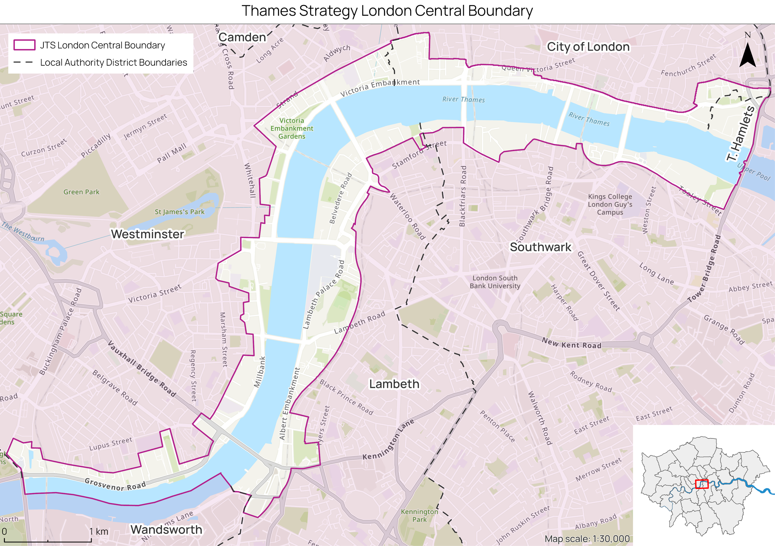
In Thames Strategy London Central, this includes:
Chelsea to Westminster: Predominantly residential with significant leisure spaces, upscale residential areas, cultural institutions and recreational spaces
Westminster to South Bank: Cultural hub with a mix of institutional buildings, cultural venues and public spaces
Blackfriars to City: A mix of historic architecture, financial institutions, and commercial developments.
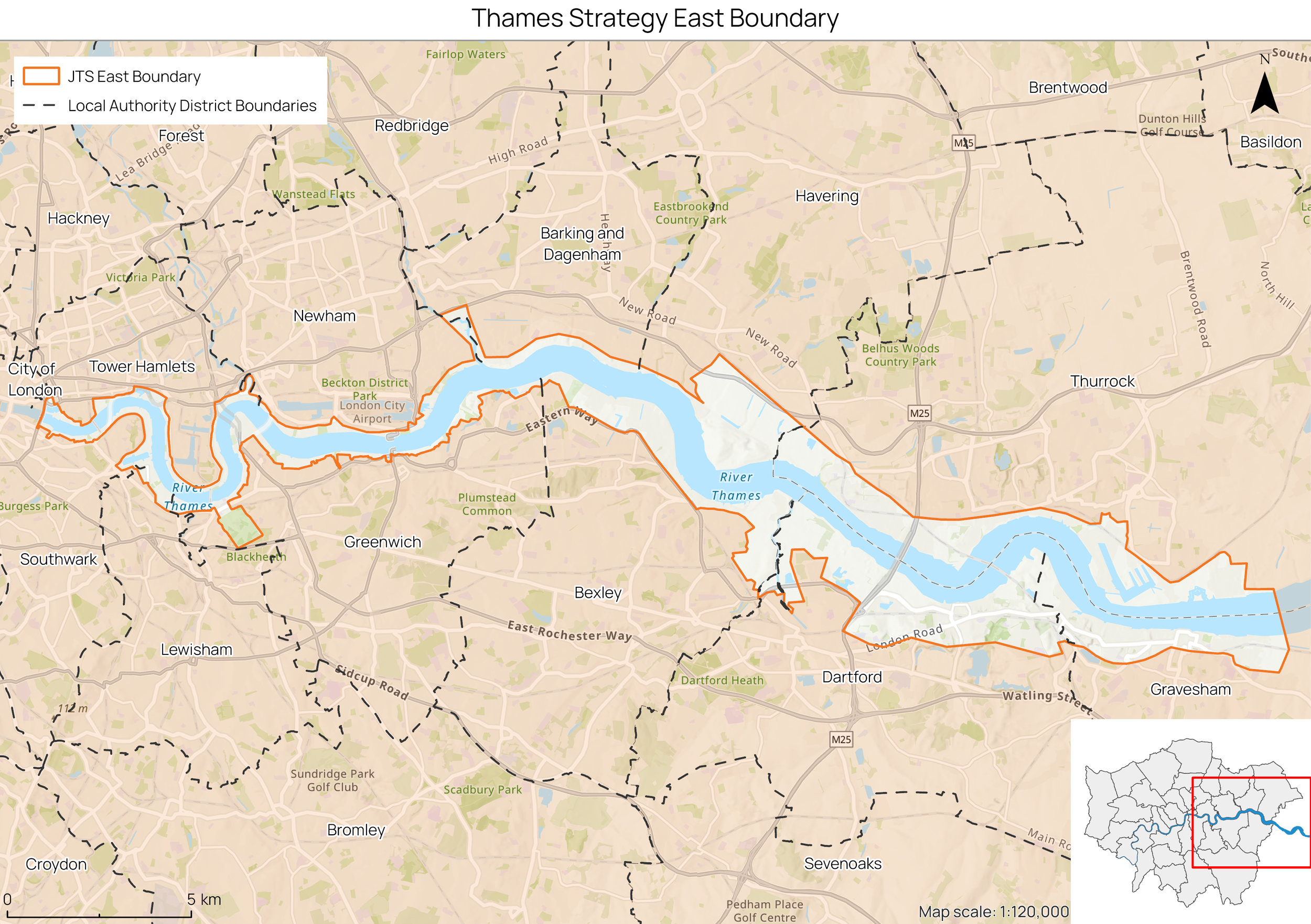
Within Thames Strategy East, the reaches include:
Upper Pool, Lower Pool and Limehouse Reach - characterised by a mix of large historic brick wharf buildings and new riverside developments.
Limehouse, Greenwich and Blackwell Reach - characterised as an enclosed river corridor with densely built-up frontages.
Bugsby and Woolwich Reach - mainly industrial, with a number of working wharves, boat yards and commercial estates.
Gallions and Barking Reach - characterised by extensive areas of industrial and previously developed land on the northern bank and development sites on the southern bank.
Halfway and Erith Reach - characterised by an active heavy industrial riverside and utilities’ infrastructure.
Erith Rands Reach - characterised by extensive areas of marshland.
Long Reach and Fiddler’s Reach – characterised by a patchwork of land uses including large scale heavy industrial complexes, container depots, recent commercial and office development, as well as remnants of marshland and pockets of residential development.
Northfleet Hope Reach - characterised by shipping activity, dock cranes, large warehouses and depots.
Gravesend Reach - The northern bank has a mixed character with grazing marsh extending down to the river, and the southern bank has a mainly urban character
These reaches, as well as the recommendations made in the strategy will be updated through Landscape Character Assessments that will be undertaken in this area.
The goal of this newsletter is not only to update you on the progress of these strategies but also to bring you in to help shape the conversations happening between these reaches. It is the stories and experiences, big and small, that make up our relationship with the Thames, and which will help us create a strategy that supports and protects life in and around the Thames.
What’s next?
One of the most crucial aspects of our work is our ability to connect with the people to whom the Thames means so much. As a key element of London, the Thames has provided work, leisure, safety, interest and calm, and all of which carry with them the good and bad parts of interacting with such an iconic river.
So, as the strategies progress, we want to ask you: How can we improve our relationship with the riverside?
We have put together this survey, and we would really appreciate all your input. Your help will ensure that we put forward the best possible strategies to protect and enhance your riverside!